Beddgelert Walks and Walking Guide
Snowdonia, Gwynedd
Find circular walks near Beddgelert which is located in the shadow of Snowdon and is a perfect place from which to explore the area on foot. There are a variety of local amenities including cafés, bars and restaurants. Accommodation including camp sites and caravan parks is readily available. Public transport is limited but the Snowdon Sherpa service provides excellent links for walkers during the season.
All walks are free to download and print, and all routes have mapping and GPX files. Highlights include an ascent of Moel Hebog which can started in the village. Not far away are starting points for walks to Snowdon's summit including the quieter routes from Rhydd-Ddu. Easy walks are available in this area too with Cwm Bychan and Aberglaslyn popular walks. The outstanding Nantlle Ridge is also easy to reach and will provide a superb day in the hills. Finally exploring Cnicht and the Moelwyns from Croesor can be easily reached.
★ = GPS file available
| Walk | Description | Grade | Miles |
|---|---|---|---|
| 1427★ | Craflwyn circular from near Beddgelert | easy/mod | 2.50 |
| 3074★ | Mynydd Sygun from Beddgelert | moderate | 4.50 |
| 1454★ | Glyder Fawr & Glyder Fach from Pen-y-Pass | mod/hard | 5.50 |
| 1799★ | Moel Hebog from Beddgelert | moderate | 5.50 |
| 1136★ | Yr Aran (Route 2) from Bethania | moderate | 5.50 |
| 1426★ | Aberglaslyn and Cwm Bychan from Beddgelert | easy/mod | 5.75 |
| 2150★ | Llyn Dinas and Cwm Bychan from Beddgelert | easy/mod | 6.00 |
| 1951★ | Mynydd Mawr from Rhyd-Ddu | moderate | 6.00 |
| 2590★ | Nantlle Ridge Walk from Rhyd Ddu (Route A) | moderate | 6.00 |
| 1127★ | Cnicht from Croesor | moderate | 6.25 |
| 2560★ | Moel Hebog, Moel yr Ogof & Moel Lefn from Beddgelert | mod/hard | 6.50 |
| 1192★ | Yr Aran from Bethania | mod/hard | 6.50 |
| 1988★ | Beddgelert, Moel Hebog, Meol yr Ogof & Moel Lefn | mod/hard | 6.75 |
| 3231★ | Moel Hebog, Meol yr Ogof and Moel Lefn from Beddgelert | mod/hard | 6.75 |
| 3060★ | Moel Lefn & Moel yr Ogof from Cwm Pennant | moderate | 7.00 |
| 1958★ | The Snowdon Horseshoe from Pen-y-pass | hard | 7.50 |
| 3198★ | Snowdon via the South Ridge & Rhyd-ddu Path | mod/hard | 7.50 |
| 2729★ | Snowdon by Rhyd-Ddu and Snowdon Ranger Paths | mod/hard | 7.50 |
| 1216★ | Y Lliwedd & Snowdon from Pen-y-pass | mod/hard | 7.50 |
| 3035★ | The Moelwyns from Croesor | mod/hard | 7.50 |
| 1089★ | Snowdon by the Pyg and Miner's Tracks from Pen-y-pass | moderate | 7.50 |
| 2692★ | Snowdon via Dinas Mot & Crib Goch from Pen-y-pass | hard | 8.00 |
| 2290★ | Snowdon via the Watkin Path & South Ridge from Bethania | mod/hard | 8.00 |
| 1422★ | Cnicht and Moelwyn Mawr from Croesor | moderate | 8.00 |
| 3509★ | Nantlle Ridge from Rhyd Ddu (Route B) | mod/hard | 8.25 |
| 2797★ | Yr Aran and Snowdon from Rhyd-Ddu | mod/hard | 8.50 |
| 3058★ | Llyn yr Adar & Llyn Edno from near Bethania | moderate | 9.00 |
| 1010★ | Cnicht, Moel Druman & Allt-fawr from Croesor | moderate | 10.00 |
| 1515★ | Tops and Tarns of the Moelwyns from Bethania | mod/hard | 11.00 |
| 1103★ | Snowdon & Cwm Llan horseshoe | very hard | 13.00 |
The walks listed above are the nearest 30 from Beddgelert when measured in a straight line.
Recommended Reading
Snowdonia: 30 Low-level and easy walks - North
 Guidebook describing 30 walks in Snowdonia, Wales. Routes are mostly low level and on clear paths and showcase the region's beautiful scenery and rich history and culture. Part of a 2-volume set, this northern volume includes the Snowdon area, the Ogwen and Conwy Valleys, Betws-y-Coed, Beddgelert, Ffestiniog and the coast.
More information
Snowdonia: 30 Low-level and easy walks - South
 Guidebook describing 30 walks in Snowdonia, Wales. Routes are mostly low level and on clear paths and showcase the region's beautiful scenery and rich history and culture. Part of a 2-volume set, this southern volume includes Trawsfynydd, Bala, Dolgellau, Machynlleth, the Harlech Coast and the valleys of the Mawddach and Dyfi.
More information
Further Information
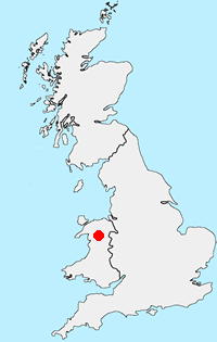
Walk Location Map
Walking in Snowdonia
Walking in TSnowdonia (Eryri) National Park is much more than the highest mountain in England and Wales. Mainly mountainous, it encompasses a large area of beautiful and often spectacular wild landscapes. Located in North Wales, the National Park offers a tremendous variety of walks with many challenging mountain routes. More Information
Walk grading - Learn how each walk is assessed and select a walk to suit your ability and experience by going to Walk Grading Details.
Messaging & Social Media
Message Walking Britain and follow the latest news.

Mountain Weather
Stay safe on the mountains with detailed weather forecasts - for iOS devices or for Android devices.