Amersham Old Town Circular
Buckinghamshire Walk
County/Area - Buckinghamshire - South Buckinghamshire
Author - Peter Smyly
Length - 11.5 miles / 18.7 km Ascent - 600 feet / 182 metres
Time - 6 hours 20 minutes Grade - easy/mod
Maps 

| Ordnance Survey Explorer 172 | Sheet Map | 1:25k | BUY |
| Anquet OS Explorer 172 | Digital Map | 1:25k | BUY |
| Ordnance Survey Landranger 165 | Sheet Map | 1:50k | BUY |
| Anquet OS Landranger 165 | Digital Map | 1:50k | BUY |
Walk Route Description
Click image to visit gallery of 8 images.
This circular walk in rural Buckinghamshire visits a few villages, Penn Street, Tylers Green, Winchmore Hill and Coleshill. The walk involves crossing a few busy main roads where the only sensible option is to wait for a break in the traffic and then cross with care. Some sections are relatively dull where the route follows muddy paths through woodland with no views. At other times, the views open up as the landscape is revealed. There are also some pretty water features - Shardeloes Lake, the River Misbourne and the duck pond at Coleshill, the latter of which is notable for its reflections. Tylers Green and Penn Street each have a duck pond too.
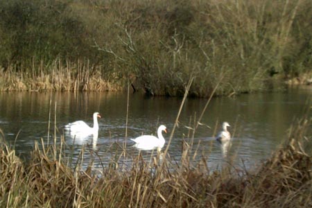
From Amersham Old Town, walk along Whielden Street away from Broadway due south-west and, immediately after a pink house on the right, a public footpath sign appears indicating the way to go next along a road called The Platt. The route leads past cottages and crosses a minor road and a major road, the A41, to cross a field. Shardeloes Estate is seen ahead and, at a fork in the path, take the right branch leading to the cricket field, beyond which, a path leads past woodland on the right and Shardeloes Lake shortly comes into view beyond the trees. The path emerges into the open to run alongside the lake and the noise from the busy A41 beyond the lake is apparent. The lake is a popular spot for water fowl and three swans appeared when I did this walk in February 2014. This part of the South Bucks Way leads to a crossroads and Mop End Lane is the way to go next, a stony lane leading uphill on the left. There was evidence of recent heavy rainfall and flooding with the nearby River Misbourne having overflowed its banks and created two new temporary duck ponds in a field near to Kennel Farm.
At the end of Mop End Lane, the route leads past Mop End Farm. Take the road straight ahead due south and turn left at the T junction. This is the second busy main road to be crossed. The road leading to the next village, Penn Street, is reached via the next road on the right. The road passes the church on the right and leads to the village green which has a pond and an obelisk. Beyond the green, follow the road due south-west to the next T junction and turn left along Gravelly Way, then a signed public footpath off to the right leading up through Common Wood. The route leads uphill before levelling out and then going down again to reach the next road, Common Wood Lane. Here there is space for a few cars to park by the road. Across the other side of the road, a footpath leads up through Pugh's Wood briefly before emerging into the open. Here there is a choice of routes but for this route, bear right across a field to reach and follow alongside the main road running through Tylers Green.
After passing the duck pond, leave the main road to take the road called Beacon Hill on the right. This is a slight digression that leads away from the busy main road up through a residential area and enables Beacon Hill itself to be glimpsed on the right, albeit by way of a slight detour down a path to the right, but for the continuation of this route, turn left off the road to follow a signed path. This path joins up with the Chiltern Way, after a sign in a field warning walkers to "Beware of the ram" which may not be seen anyway. After rejoining the main road, cross it, and follow the continuation of the Chiltern Way as it borders Twichels Wood (though there is also an alternative path through the wood itself that runs alongside) before going round to the right to edge a field as it continues to a minor road that leads to a small triangular green at Penn Bottom. Beyond the road, the route leads up past one wood and then through another to reach a tarmac road which, after a few minutes walking, appears to be bending too much round to the left. Just when it does this, a clearing appears on the right, revealing the waymarked continuation of the Chiltern Way. The route now leads on to the next village, Winchmore Hill, passing Gawde Water next to Horsemoor Lane, a pond, described by a nearby notice board as "gourd shaped" but the outline defies description after heavy rainfall.
The Chiltern Way leads away from Winchmore Hill and on to the next one, Coleshill, with its church, pub (Red Lion) and duck pond with a couple of wooden seats. From the duck pond, leave Coleshill, via a path to the left of the pub, through woodland initially before crossing a field. Before reaching the busy Amersham Road., keep an eye out for a path on the left, confirmation of which comes in the form of a sign post on the right indicating a crossroads of paths and follow this across a field and then uphill past a cultivated field left with an "island" of Scots Pines. Follow Tower Road ahead and at the next turning take a narrow path down to the left past an isolated house. This path follows the edge of a field and then presents a choice at a fork. Bear diagonally left here along a faint path across a field. Amersham Old Town is seen ahead and next the path leads down to the very busy A413 before continuing on the other side to rejoin Whielden Road.
Other walks nearby
| Walk 2928 | Amersham to Chorleywood via Chalfont St Giles | easy/mod | 8.5 miles |
| Walk 1517 | Amersham circular via Hyde Heath and Little Missenden | easy/mod | 8.0 miles |
| Walk 1071 | Chalfont & Latimer, Chalfont St Giles & Chorleywood | easy/mod | 12.6 miles |
| Walk 1536 | Sarratt Bottom and Chenies from Little Chalfont | easy/mod | 6.3 miles |
| Walk 1568 | Chalfont and Latimer, Flaunden and Chorleywood | moderate | 11.7 miles |
| Walk 3443 | Chalfont & Latimer, Latimer and Flaunden | moderate | 13.7 miles |
| Walk 1149 | Chesham to Rickmansworth (Chess Valley) | easy/mod | 10.5 miles |
| Walk 1060 | Little Missenden and Amersham | easy/mod | 8.5 miles |
| Walk 1392 | Chesham & Cholesbury Circular | moderate | 16.0 miles |
| Walk 2369 | Chesham & Little Missenden Circular | easy/mod | 9.4 miles |
Recommended Books & eBooks
No suggestions for this area.Messaging & Social Media
Message Walking Britain and follow the latest news.

Mountain Weather
Stay safe on the mountains with detailed weather forecasts - for iOS devices or for Android devices.