Helvellyn & Dollywaggon Pike from Wythburn
Lake District Walk
Nat Park - Lake District - Lake District Eastern Fells
Wainwrights - Dolltwaggon Pike, Helvellyn, Nethermost Pike
County/Area - Cumbria
Author - Lou Johnson
Length - 8.0 miles / 13 km Ascent - 2870 feet / 870 metres
Time - 6 hours 50 minutes Grade - moderate
Maps 

| Ordnance Survey Explorer OL5 | Sheet Map | 1:25k | BUY |
| Anquet OS Explorer OL5 | Digital Map | 1:25k | BUY |
| Ordnance Survey Landranger 90 | Sheet Map | 1:50k | BUY |
| Anquet OS Landranger 90 | Digital Map | 1:50k | BUY |
Walk Route Description
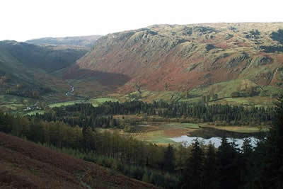
Click image to visit gallery of 12 images.
This Lake District walk to the summit of Helvellyn is straight forward with none of the challenges encountered when using an approach from Glenridding over Striding Edge. The whole route is on clearly marked paths although it must be remembered that with cloud sitting on the 'tops' then navigation skills would be required.
The start is the small car park adjacent to Wythburn Church (grid ref. NY324136) just off the A591 Grasmere to Keswick road. On busy days this is likely to fill early although there is other limited parking available in the vicinity. Exit the car park through the gate on the eastern side and follow the steep path up through the conifers. Reaching a cross track, which is used on the return, continue straight ahead continuing to climb.
Gaining height quickly you reach the open fell with the path visible up to your right. The path has been improved and after negotiating a series of zigzags you have completed the steepest part of the climb. It must be stressed that it is not a 'slog' as the surroundings are pleasant and the views improving as you climb. Ahead lies the most tedious section as you climb across Birk Side to the col between Nethermost Pike and Helvellyn. Reaching this col you get a great view of Striding Edge. The final climb to the summit of Helvellyn is straightforward and you are soon enjoying a 360 degree view.
From the summit of Helvellyn retrace your steps south to the col mentioned in the previous paragraph. Take the left fork ignoring the path used for the ascent and continue to the summit of Nethermost Pike. The preferred route is to ignore the main path, which takes a rather boring route, instead staying as close to the edge of the crags around Nethermost Cove. This route involves a little more ascent but the views are spectacular and worth the extra effort. From Nethermost Pike continue south over High Crag and onto the summit of Dollywaggon Pike where a promontory provides a grandstand view down Grisedale to Ullswater.
From Dollywaggon Pike the next objective is Grisedale Tarn. The path zigzags down the fellside losing nearly 1000 feet in the process. During the descent you get good views of St Sunday Crag, Fairfield and Cofa Pike. Reaching the Tarn cross the stepping stones across the outlet stream and climb south-westwards to Grisedale Hause. Turn right here following the path north-east to reach a minor col (grid ref. 344121). Staying on this path you descend to Dunmail Raise following Raise Back with its pretty waterfalls and cascades. Reaching the main road turn north and pick up the signed concession path that contours through fields to reach a conifer plantation (grid ref. 327125). Follow the forest track back to the start turning left on the path used for the outward route.
Other walks nearby
| Walk 1247 | Helvellyn & Raise from Swirls | mod/hard | 7.0 miles |
| Walk 2025 | Helvellyn & Wythburn from Swirls | mod/hard | 8.5 miles |
| Walk 3132 | High Tove & Blea Tarn | moderate | 7.6 miles |
| Walk 2254 | Grisedale Tarn from Grasmere | moderate | 5.5 miles |
| Walk 2841 | Seat Sandal via Grisedale Tarn from Grasmere | moderate | 5.0 miles |
| Walk 2932 | Green Burn horseshoe from Grasmere | moderate | 7.0 miles |
| Walk 2525 | Standing Crag & Dock Tarn from Watendlath | moderate | 7.0 miles |
| Walk 2526 | Standing Crag, Ullscarf & Borrowdale | mod/hard | 10.0 miles |
| Walk 2019 | Raven Crag, the Benn & Shoulthwaite Gill near Thirlmere | easy/mod | 4.0 miles |
| Walk 2032 | Great How, a short ascent above Thirlmere | easy | 2.0 miles |
Recommended Books & eBooks
Lake District: High Level and Fell Walks
 This guidebook describes 30 graded fell walks on the ridges and high peaks of the English Lake District, the UK's most popular national park. Reaching some of England's finest and highest mountain scenery, this guide leads readers to classic horseshoes and traditional ascents as well as lesser-known routes to quieter summits.
More information
Walking the Lake District Fells - Langdale
 Part of the Walking the Lake District Fells series, this guidebook covers a wide range of routes to 25 Lakeland summits that can be climbed from the Great Langdale valley, Ambleside and Grasmere, with highlights including Scafell Pike, Bowfell, the Langdale Pikes and Helm Crag (the Lion and the Lamb). Includes suggestions for longer ridge routes.
More information
Messaging & Social Media
Message Walking Britain and follow the latest news.

Mountain Weather
Stay safe on the mountains with detailed weather forecasts - for iOS devices or for Android devices.