Carsington Water, Hognaston & Madge Hill
Derbyshire Walk
County/Area - Derbyshire - South East Derbyshire
Author - Lou Johnson
Length - 5.5 miles / 8.9 km Ascent - 700 feet / 212 metres
Time - 3 hours 30 minutes Grade - easy/mod
Maps 

| Ordnance Survey Explorer OL24 | Sheet Map | 1:25k | BUY |
| Anquet OS Explorer OL24 | Digital Map | 1:25k | BUY |
Walk Route Description
Click image to see photo description.
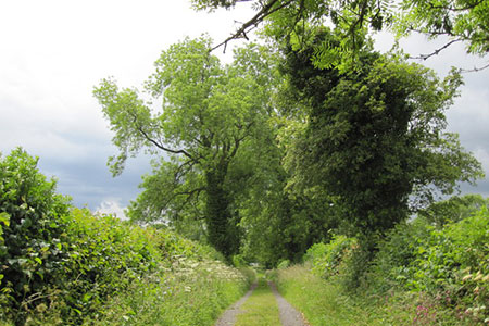
The circular walk in Derbyshire starts from the Carsington Water Visitor Centre and visits the village of Hognaston and its fine parish church. The walk then crosses fields to reach Madge Hill from where there are good views across the surrounding countryside and Carsington Water. The return route crosses fields back to the start. The walk lies outside the boundaries of the nearby Peak District National Park, but despite this, passes through some pretty, rolling countryside.
The start is the large pay and display car park adjacent to Carsington Water Visitor Centre (grid ref. SK241517), which can be reached by taking the B5035 from Ashbourne. After parking walk towards the Visitor Centre and locate the tarmac cycle path. Turn left along the cycle path and after 150 metres turn right at footpath fingerpost and cross the road. Follow the waymarks as the path crosses several fields to reach Enslet Lane (grid ref. SK237512). Turn left and after 200 metres follow the waymarks right and continue along the path to join Green Lane. Follow this lane uphill to St Bartholomew's church and the 'main' road through the village of Hognaston.
Turn left with the church on your left and then right onto a signed footpath by the bus stop (grid ref. SK235505). Entering the first field, initially walk half left (south) soon crossing a small stream. Maintain direction, following waymarks, across several more fields to pass Allow Mill (grid ref. SK232495). Maintain direction across two more fields to reach Jolly Lane by Highfields Farm (grid ref. SK232490).
Turn right along Jolly Lane and after 120 metres turn right into Winn Lane. Continue along Winn Lane for 800 metres to reach Shaws where you join a field on the north side of the property that leads to Atlow Winn (grid ref. SK222494). Do not turn right at Atlow Winn, instead keep ahead to join a field path that crosses several fields to join a lane just north of Madge Hill (grid ref. SK219498). Turn right along the lane. After 400 metres turn right up some steps to follow a waymarked path across fields for 1.5 kilometres to reach Hognaston (grid ref SK233507). Turn right along the road and then left into Green Lane just before the church. Retrace the outward route back to the start.
Other walks nearby
| Walk 2701 | Harboro Rocks & Brassington | easy/mod | 6.5 miles |
| Walk 1378 | Carsington Circular | easy | 4.5 miles |
| Walk 1379 | Carsington and Harboro Rocks | easy/mod | 5.8 miles |
| Walk 2993 | Carsington, Brassington & Cromford and High Peak Railway from Middleton | moderate | 9.5 miles |
| Walk 1892 | Minninglow & Roystone Rocks | easy/mod | 5.8 miles |
| Walk 1410 | Minninglow Hill, Roystone Grange and Cardlemere Lane from Gotham | easy/mod | 5.5 miles |
| Walk 2627 | Cromford to Bakewell | moderate | 11.5 miles |
| Walk 2899 | Cromford Canal & Black Rocks from High Peak Junction | easy/mod | 6.8 miles |
| Walk 2559 | Stanton Moor & The Nine Ladies Stones from Winster | moderate | 9.0 miles |
| Walk 3196 | Stanton Moor and Robin Hood's Stride from Winster | easy/mod | 7.0 miles |
Recommended Books & eBooks
Walking in Derbyshire
 Walking guidebook to 60 circular day walks in Derbyshire and the Peak District. Includes the Derwent, Wye and Trent river valleys, near Derby, Matlock, Glossop, Bakewell and Ripley. Routes range from easy to moderate and are between 4 and 14km (2 to 10 miles). Walks focus on places of interest, from Stone Age forts to castles to grand estates.
More information
Walking in the Peak District - White Peak East
 Guidebook describing 42 half-day and day walks in the limestone landscapes of Derbyshire's White Peak, part of the Peak District National Park. One of two volumes, this book covers the east of the region, with potential bases including Bakewell, Eyam, Castleton, Birchover, Matlock and Wirksworth.
More information
Messaging & Social Media
Message Walking Britain and follow the latest news.

Mountain Weather
Stay safe on the mountains with detailed weather forecasts - for iOS devices or for Android devices.