Copplestone Gate and Conistone Pie from Conistone
Yorkshire Dales Walk
Nat Park - Yorkshire Dales - Upper Wharfedale
County/Area - North Yorkshire
Author - Lou Johnson
Length - 7.0 miles / 11.4 km Ascent - 1300 feet / 394 metres
Time - 4 hours 50 minutes Grade - easy/mod
Maps 

| Ordnance Survey Explorer OL2 | Sheet Map | 1:25k | BUY |
| Anquet OS Explorer OL2 | Digital Map | 1:25k | BUY |
| Ordnance Survey Landranger 98 | Sheet Map | 1:50k | BUY |
| Anquet OS Landranger 98 | Digital Map | 1:50k | BUY |
Walk Route Description
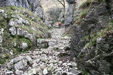
Click image to visit gallery of 12 images.
An interesting Yorkshire Dales walk that explores the high ground east of Wharfedale above the village of Conistone. The route includes the Conistone Dib, a limestone gorge, the gritstone ridge by Capplestone Gate and a section of the Dales Way that includes the Conistone Pie.
The start is the small parking areas on either side of the bridge over the Wharfe between the main road at Kilnsey Crag and Conistone village (Grid ref. SD978675). From here walk into the village and keep to the left of the small village green with its maypole. Continue straight ahead on a track with some cottages on your left. This leads into a path passing through a narrow trough to enter a wider section of valley. Quite soon the valley narrows and you enter the rocky confines of Conistone Dib.
Continue to the top of the valley emerging onto a track. Turn left along this and then enter Bycliffe Road (Grid ref. SD992682) using the gate. Turn right along this old packhorse route. The track becomes walled. Where it turns sharp right, bear left through a gate and follow the path, which turns right (northeast) towards a conifer plantation, which is passed on your left. The onward path leads towards the left of a gritstone outcrop and on to the OS trig point at Capplestone Gate (Grid ref. SE001699). Cross the wall and follow the clear path through some old lead mine spoil heaps. Ignore the path crossing (Grid ref. SE001703) and continue straight ahead keeping the wall to your left.
Reaching another path junction (Grid ref. SD997708) cross the wall using the stile and descend the pasture. The path develops into a track. However note that the right of way does not follow this track but assumes a different route to the south. Whichever route you choose, continue to lose height aiming for the southerly corner of a plantation (Grid ref. SD981705) and the Dales Way. Turn sharp left here and follow the Dales Way south across Swineber Scar. The going is easy and progress is fast as you make for the top of Conistone Dib.
Look out for a 'pork pie' shaped limestone outcrop on your right (Grid ref. SD988685) - this is the Conistone Pie! After inspecting this rather interesting shaped outcrop continue south along the Dales Way to reach Bycliffe Road. Rather than descending into the Dib, turn right along the Track into what becomes Scot Gate Lane. This takes you downhill to a tarmac lane. Turn left and you soon reach Conistone and the road leading back to the start.
Other walks nearby
| Walk 2332 | Mastilles Lane & Bordley from Kilnsey | easy/mod | 6.8 miles |
| Walk 1145 | Grassington, Mastilles Lane & Conistone Dib | moderate | 11.3 miles |
| Walk 1645 | Grassington, Mastilles Lane & Conistone Dib | moderate | 12.0 miles |
| Walk 1846 | Garnshaw House & Linton Falls from Grassington | easy | 3.0 miles |
| Walk 1250 | Great Whernside | moderate | 8.0 miles |
| Walk 1277 | Starbotton & Kettlewell circular | easy/mod | 5.0 miles |
| Walk 1294 | Arncliffe & Kettlewell Circular | moderate | 7.0 miles |
| Walk 1632 | Arncliffe & Starbotton from Kettlewell | moderate | 7.0 miles |
| Walk 1292 | Linton & Thorpe Fell & Cracoe | moderate | 9.0 miles |
| Walk 1407 | Thorpe & Burnsall from Linton | easy/mod | 6.2 miles |
Recommended Books & eBooks
Trail and Fell Running in the Yorkshire Dales
 Guidebook to 40 of the best trail and fell runs in the Yorkshire Dales National Park. Ranging from 5 to 24 miles, the graded runs start from bases such as Ribblehead, Dent, Sedbergh, Malham and Grassington and take in the region's diverse delights, from castles and waterfalls to iconic mountains such as Whernside, Ingleborough and Pen Y Ghent.
More information
Walking in the Yorkshire Dales: North and East
 This guidebook contains 43 circular day walks in the north and east Yorkshire Dales. It explores the dales, hills and moors between Kirkby Stephen and Pateley Bridge. Walking ranges from gentle 3 mile strolls to more strenuous day-long rambles across the Howgills, Wensleydale, Swaledale, Nidderdale, Mallerstang and Coverdale.
More information
Messaging & Social Media
Message Walking Britain and follow the latest news.

Mountain Weather
Stay safe on the mountains with detailed weather forecasts - for iOS devices or for Android devices.