Ingleton Waterfalls Walk
Yorkshire Dales Walk
Nat Park - Yorkshire Dales - Three Peaks Country
County/Area - North Yorkshire
Author - Lou Johnson
Length - 4.3 miles / 7 km Ascent - 750 feet / 227 metres
Time - 2 hours 50 minutes Grade - easy
Maps 

| Ordnance Survey Explorer OL2 | Sheet Map | 1:25k | BUY |
| Anquet OS Explorer OL2 | Digital Map | 1:25k | BUY |
Walk Route Description
Click image to visit gallery of 11 images.
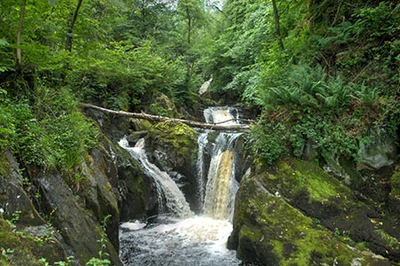
The Ingleton Waterfalls Walk in the Yorkshire Dales was described by A W Wainwright as "the most delightful walk in the country?" The walk includes two valleys with a variety of waterfalls and a stretch of open limestone country. Who could ask for more? Starting from Ingleton, the route is normally undertaken in a clockwise direction and takes a few hours to complete and is perhaps best seen after heavy rain. The walk is also an attractive proposition even in periods of dry weather.
Ingleton village offers a range of parking opportunities. You can use the main pay and display car park adjacent to the excellent information centre (grid ref. SD694730), on-street parking (in short supply at busy weekends) or the large car park at the entrance to the walk (grid ref. SD693732). Whichever option you choose, make your way to the entrance to the walk, which is signed throughout the village. There is a charge of £6 for adults which includes free parking at the start of the walk.
Directions for the walk are not necessary as the path is easy to follow and well maintained. There are many steps to negotiate and the route is not ideal for those with pushchairs. Young children need careful 'management' as there are several steep drops off the path into the rivers. Refreshments are available at the start of the walk and twice during the walk (in season). Often there is also an ice-cream van parked conveniently on Twisleton lane.
After parking follow the River Twist upstream through Swilla Glen passing through pleasant woodland. The entrance fee includes a map which highlights the main waterfalls to be encountered along the way. The path climbs steadily and makes two crossings of the river. Eventually you reach open country and Thornton Force the highest waterfall on the route. The path then leaves the river valley and climbs up to Twisleton Lane.
The route turns right along the walled lane and continues past Twisleton Hall and down to Beezleys. On this section, you have some fine views of Ingleborough. From Beezleys the path descends alongside the River Doe passing more waterfalls on the way back to the start. The path finishes in Ingleton village with a plentiful supply of refreshment opportunities. If you have parked at the entrance to the walk then you will need to walk down to the car park from the village.
Other walks nearby
| Walk 2256 | Great Stone of Fourstones | easy/mod | 6.7 miles |
| Walk 3584 | Gragareth from Ireby | moderate | 7.4 miles |
| Walk 3032 | Gragareth & Great Coum from Yordas Cave | moderate | 9.0 miles |
| Walk 2376 | Gragareth from Leck | moderate | 9.3 miles |
| Walk 1248 | Trow Gill, Ingleborough & Long Scar | moderate | 9.5 miles |
| Walk 2796 | Ingleborough via Gaping Gill & Norber | moderate | 13.0 miles |
| Walk 3599 | Clapham, Oxenber Woods, Feizor & Settle | easy/mod | 7.5 miles |
| Walk 3094 | Norber & Norber Erractics | easy/mod | 6.3 miles |
| Walk 1208 | Ingleborough & Park Fell | moderate | 7.5 miles |
| Walk 3500 | Ingleborough (northern approach) | moderate | 9.5 miles |
Recommended Books & eBooks
Walking in the Yorkshire Dales: South and West
 Part of a two-book set, this guidebook describes 44 walks in the southern and western Yorkshire Dales, including the famous 23 mile Three Peaks circuit over Pen-y-Ghent, Whernside and Ingleborough. The other, mostly circular routes of 3½ to 13 miles cover the scenic region between Sedbergh, Kirkby Lonsdale, Settle, Skipton and Grassington.
More information
Walking in the Yorkshire Dales: North and East
 This guidebook contains 43 circular day walks in the north and east Yorkshire Dales. It explores the dales, hills and moors between Kirkby Stephen and Pateley Bridge. Walking ranges from gentle 3 mile strolls to more strenuous day-long rambles across the Howgills, Wensleydale, Swaledale, Nidderdale, Mallerstang and Coverdale.
More information
Messaging & Social Media
Message Walking Britain and follow the latest news.

Mountain Weather
Stay safe on the mountains with detailed weather forecasts - for iOS devices or for Android devices.