Aran Fawddwy northern approach from Esgair-gawr farm
Snowdonia/Eryri Walk
Nat Park - Snowdonia - Arans Lake Bala
County/Area - Gwynedd
Author - Lou Johnson
Length - 8.4 miles / 13.7 km Ascent - 2450 feet / 742 metres
Time - 6 hours 40 minutes Grade - mod/hard
Maps 

| Ordnance Survey Explorer OL23 | Sheet Map | 1:25k | BUY |
| Anquet OS Explorer OL23 | Digital Map | 1:25k | BUY |
Walk Route Description
Click image to see photo description.
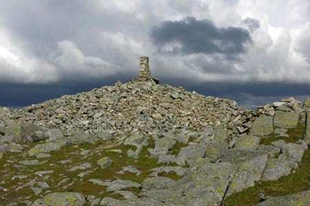
Aran Fawddwy, lying to the South of Lake Bala, is the highest summit on a long ridge. Rising to 905 metres above sea level it offers wonderful views over much of Snowdonia (Eryri). The most popular approach is the southern route from the Cwm Cywarch with the eastern approach along the ridge also gaining in popularity. This route starts from the north and offers some challenges with navigation with the relevant OS 1:25000 map a necessity. The route is described in less detail than with other walks primarily to deter less experienced walkers who should not be attempting this walk.
The start of this Snowdonia (Eryri) walk is the small parking area at grid ref. SH815223 on the lane south of Esgair-gawr farm just off the A494 road from Bala to Dolgellau. After parking, walk southwest up the lane for approximately 700 metres to grid ref. SH812217. Turn left on a clear track rising in a southerly direction to reach the edge of Coed-y-Brenin forest. Just after entering the trees, turn left onto a clear path to reach a wider track after about 100 metres. Careful navigation is now required with frequent reference to your map.
Turn left on the main track and follow this for about a mile to reach an open area at grid ref. SH 828208. Fork right here following the marker arrow. The track zig-zags uphill to reach the end of the forest at grid ref. SH833206. Cross the stile into open hillside. From here an indistinct path leads uphill with a stream to your left. After 600 metres, the path bears left away from the stream and eventually reaches a fence. Turn left along the fence now following the main ascent route and continue to the summit of Aran Fawddwy (grid ref. SH862224) from where you can enjoy the extensive panorama.
Retrace your steps down the path beside the fence used for the ascent. Continue for about a kilometre to grid ref. SH855216. There is an intermittent path heading north, which roughly follows the route detailed on the OS map. However, I had problems keeping on the path and with careful use of my map made my way down to the edge of the forest at grid ref. SH837221). Cross the stile and follow a narrow track heading just west of north to reach a wider track and turning circle (grid ref. SH836223). After 600 metres go straight across a wide track and continue ahead along a grassy path to exit the forest at grid ref. SH826223). You soon join an improving track that descends to Esgair-gawr farm and a lane. Turn left along the lane back to the start.
Other walks nearby
| Walk 2811 | Rhobell Fawr and Ddualt from near Rhydymain | moderate | 8.5 miles |
| Walk 1499 | Rhobell Fawr and Dduallt from Llanfachreth | moderate | 12.0 miles |
| Walk 2551 | Rhobell Fawr from near Rhydymain | moderate | 5.7 miles |
| Walk 1190 | Aran Fawddwy | mod/hard | 7.5 miles |
| Walk 3055 | Glasgwm | moderate | 4.5 miles |
| Walk 1255 | The Aran Ridge | hard | 11.2 miles |
| Walk 1400 | The Arans | hard | 14.0 miles |
| Walk 1107 | Waun Oer and Maesglase near Dinas Mawddwy | mod/hard | 11.0 miles |
| Walk 2334 | The Torrent Walk near Dolgellau | easy | 1.6 miles |
| Walk 1646 | The Precipice Walk | easy | 3.5 miles |
Recommended Books & eBooks
The Wales Coast Path
 A single guidebook to walking the whole Wales Coast Path - 1400km (870 miles) the length of Wales from Chester to Chepstow, including Anglesey, described in 57 stages. The route passes through the Snowdonia and Pembrokeshire National Parks and many AONBs and can be linked with the Offa's Dyke Path for a complete circuit of Wales.
More information
Snowdonia: 30 Low-level and easy walks - South
 Guidebook describing 30 walks in Snowdonia, Wales. Routes are mostly low level and on clear paths and showcase the region's beautiful scenery and rich history and culture. Part of a 2-volume set, this southern volume includes Trawsfynydd, Bala, Dolgellau, Machynlleth, the Harlech Coast and the valleys of the Mawddach and Dyfi.
More information
Messaging & Social Media
Message Walking Britain and follow the latest news.

Mountain Weather
Stay safe on the mountains with detailed weather forecasts - for iOS devices or for Android devices.