Walk 2474 - printer friendly version
East Prawle Coast Circular Walk
Author - Lou Johnson
Length - 5.6 miles / 9.1 km
Ascent - 800 feet / 242 metres
Grade - easy/mod
Start - OS grid reference SX781364
Lat 50.2150200 + Long -3.7098959
Postcode TQ7 2BY (approx. location only)
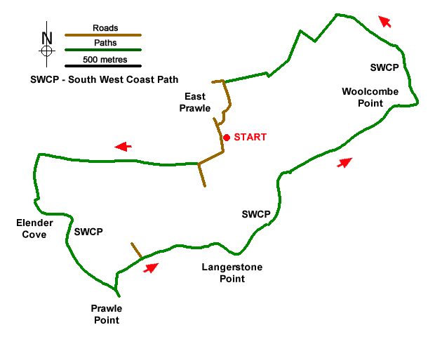
An excellent walk from East Prawle exploring the coast between Elender Cove and Woodcombe Point, the most southerly section of coast in Devon. The route uses quiet country lanes, tracks, and a section of the South West Coast Path which follows the low cliff tops past Prawle Point and Langerstone Point. At the end of the walk refreshments are available at the Pig's Nose Inn.
The walk starts from the village green in East Prawle where parking is available opposite the telephone box (grid ref. SX781364). After parking and facing the telephone box, turn left and follow the lane out of the village. After 350 metres the lane bends left. Continue ahead to join an enclosed track with a bridleway fingerpost on the left. Stay on the track for 1.3 kilometres to reach a T-junction (grid ref. SX767361). Turn left and descend steeply towards the sea. The path stays close to a wall on your right. When the wall ends descend through a rocky landscape and turn right at the first junction. The path soon joins the South West Coast Path (SWCP) above Elender Cove.
Turn left to follow the SWCP. The path runs along the tops of low cliffs, and you soon arrive at National Coastwatch lookout station on Prawle Point where there is a visitor centre offering information about this stretch of coast and its wildlife. The onward route continues along the SWCP soon passing a row of former coastguard cottages. It then continues across a raised beach with a line of landlocked cliffs on your left. The path crosses Langerstone Point. Approaching Woodcombe Sands, the SWCP turns inland and reaches a fingerpost signed East Prawle (grid ref. SX795369). Turn left off the SWCP and continue up an enclosed path.
Keep ahead and nearing the top of the climb you reach a T-junction. Turn left onto a bridleway which soon leads into an access driveway. Continue ahead and follow the clear track as it bends right. When the driveway bends right, turn left, and continue along the bridleway along the right-hand edge of a field. The track briefly passes through trees. 200 metres beyond the trees, turn right and follow the enclosed bridleway to a lane at the edge of East Prawle. Turn left and continue to a phone box. Ignore the road on the right and the left fork and keep ahead through the village to a T-junction. Turn left and soon after right to return to the village green.
Messaging & Social Media
Message Walking Britain and follow the latest news.

Mountain Weather
Stay safe on the mountains with detailed weather forecasts - for iOS devices or for Android devices.