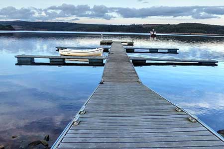
Bull Crag Peninsula (Kielder Water) from Leaplish
Lakeside Walk + Forest Walk
County/Area - Northumberland County
Author - Lou Johnson
Length - 6.3 miles / 10.2 km Ascent - 600 feet / 182 metres
Time - 3 hours 50 minutes Grade - easy/mod
Maps 

| Ordnance Survey Explorer OL41 | Sheet Map | 1:25k | BUY |
| Anquet OS Explorer OL41 | Digital Map | 1:25k | BUY |
Walk Route Description
Click image to see photo description.
Kielder Water is the largest artificial lake in England and is surrounded by the vast Kielder Forest. This circular walk explores the Bull Crag Peninsula and starts from Leaplish Waterside Park. The route is easy to follow and much of the walk follows a path alongside the lake with wide ranging views. The landscape around Kielder Water & Forest Park has become home to a unique collection of visual art and architecture to reflect the area's varied and fascinating history and examples are passed during the walk.
The walk starts from the car parks at Leaplish Water Park (grid ref. NY659878). Exit the car park and walk south passing the Waterside Lodges on your immediate left to join Lakeside Way which runs beside the lake. The path soon passes a waterski centre and continues beside the lake in a southerly direction before swinging east. Pass the Freya's Cabin installation with its partner Robin's Hut across the lake. Continue along the path around the peninsula. The next installation is Timelapse which if used as a frame captures a superb view.
The main Lakeside Way veers away from the lake and reaches a junction (grid ref. NY667864). Keep ahead following the alternative route to Kielder Waterside avoiding Bull Crag. The path soon reaches a forest track where you turn right and shortly after left towards Kielder Waterside. Reaching the lakeside path, turn left and retrace you steps to the Ski Centre. Fork left along a road which will take you back to the start.
Other walks nearby
| Walk 1477 | Bellingham to Kiln Rigg by Pennine Way Circular | moderate | 14.3 miles |
| Walk 1478 | Ladyhill to Bellingham circular | moderate | 16.0 miles |
| Walk 3343 | Hadrian's Wall, Walltown Crags & Aesica | easy/mod | 5.0 miles |
| Walk 1198 | Hadrian's Wall & Steel Rigg | moderate | 8.0 miles |
| Walk 2337 | Greenlee Lough and Steel Rigg | easy/mod | 7.5 miles |
| Walk 3404 | Hadrian's Wall - Cawfields to Steel Rigg | easy/mod | 3.5 miles |
| Walk 3331 | Cragend & Crow Crags from Housesteads | easy/mod | 8.4 miles |
| Walk 1677 | Peel Crags & Winshield Crags from Vindolanda | easy/mod | 7.8 miles |
| Walk 2671 | Hotbank Crags & Housesteads from Vindolanda | easy | 5.3 miles |
| Walk 3353 | The Roman Camp at Chew Green | easy/mod | 5.8 miles |
Recommended Books & eBooks
Walking in Northumberland
 This guidebook contains detailed route descriptions for 36 day walks in Northumberland including the Cheviot Hills. The terrain varies from wild walks and craggy ascents to gentle riverside strolls. Each route ranges from 4 to 16 miles in length and there is the opportunity to link several walks together to create longer treks.
More information
Hadrian's Wall Path
 Hadrians Wall Path guidebook to walk the 84 mile National Trail. Described in both directions, the main description is west to east between Bowness-on-Solway and Wallsend, Newcastle, with extensions to Maryport and South Shields. With extensive historical information related to this World Heritage site and separate 1:25,000 OS map booklet included.
More information
Messaging & Social Media
Message Walking Britain and follow the latest news.

Mountain Weather
Stay safe on the mountains with detailed weather forecasts - for iOS devices or for Android devices.