Clun Valley Circular
Countryside Walk + Hill Walk + Castle
Region - Shropshire Hills
County/Area - Shropshire
Author - Lou Johnson
Length - 8.1 miles / 13.2 km Ascent - 980 feet / 297 metres
Time - 5 hours 0 minutes Grade - easy/mod
Maps 

| Ordnance Survey Explorer 201 | Sheet Map | 1:25k | BUY |
| Anquet OS Explorer 201 | Digital Map | 1:25k | BUY |
| Ordnance Survey Explorer 216 | Sheet Map | 1:25k | BUY |
| Anquet OS Explorer 216 | Digital Map | 1:25k | BUY |
Walk Route Description
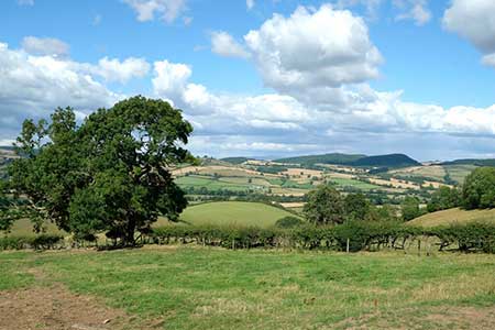
Click image to see photo description.
A lovely walk from Clun exploring the countryside west of the town. The route initially follows the Jack Mytton Way which climbs steadily across the hills to the south of the Clun Valley. The walk then joins the Offa's Dyke Path heading north into the valley. The final section of the walk follows the valley with the final section of the route using the Shropshire Way back to Clun. If time allows a visit to Clun Castle is an excellent end to the walk with an excellent view.
The start is the Clun Castle car park (grid ref. SO299808) on the north side of the B4368 west of the town. After parking, exit the car park and turn left and continue to the A488 with the bridge over the Clun to your left. Do not cross the bridge and turn right (signed to Knighton). Continue uphill to the church on your left. Take the next road on the right (Llwyn Road). Just past St George's Place on the left, turn left along a track with adjacent fingerpost. When the track turns left continue ahead along the enclosed path which loops back to Llwyn Road (grid ref. SO288803). Turn left and follow the road as it continues to climb following the Jack Mytton Way. You soon pass Llwyn Beyond this house the views across the Clun valley to the hills beyond improve.
Stay on the lane for just over a kilometre to reach a crossroads (grid ref. SO276800). Turn right towards Springhill and almost immediately left along a track signed to Burfield still following the Jack Mytton Way. There is also an adjacent fingerpost. Walk through Burfield to join a clear track. At the first junction the Jack Mytton Way goes left. Continue ahead to where the track bends left and take the signed bridleway through a gate on the right into a field. Walk half-right up the field. Go straight across a bridleway and walk up the field aiming for the left-hand end of a row of trees. The onwards path, still climbing, heads northwest to reach a lane by Springfield Farm (grid ref. SO255809).
Cross the lane to the metal gate opposite and join the Offa's Dyke Path. Continue north for a kilometre to reach the B4368. Turn left and almost immediately right to continue along the ODP. The path crosses the River Clun and leads past Bryndrinog to a lane (grid ref. SO256826). Turn right and continue for a kilometre to bridleway sign in the hedge on your right. Follow the path, initially between hedges, into a field where you keep to the left-hand hedge. The path quickly returns between hedges and continues east. The path soon joins an access track which leads to a lane south of Whitcott Keysett (grid ref. SO277825).
Bear right along the lane. Keep ahead at the next junction and continue for a kilometre where the Shropshire Way crosses the road (grid ref. SO286820). Turn right at the fingerpost and follow the path which trends southeast to meet the River Unk. Bear right beside the river and continue to a footbridge. Cross the river and continue towards Clun. Reaching the outskirts of the town you pass a row of houses on the left and join a lane which soon turns sharp left. Pass through the metal gate ahead and follow the path which leads to Clun Castle. Pass through the grounds to reach the car park used at the start of the walk.
Other walks nearby
| Walk 2814 | Corndon Hill from Priest Weston | easy | 1.5 miles |
| Walk 2395 | Mitchell's Fold & Bromlow Callow | easy/mod | 6.1 miles |
| Walk 2054 | Linley Hill & Beeches from Wentnor | easy/mod | 7.0 miles |
| Walk 1809 | Shelve & the Stiperstones from The Bog | moderate | 9.0 miles |
| Walk 2083 | Linley Hill and Linley from The Bog | moderate | 8.5 miles |
| Walk 3395 | The Stiperstones Ridge | easy/mod | 5.5 miles |
| Walk 3422 | Ratlinghope & the Stiperstones from the Knolls | moderate | 7.5 miles |
| Walk 3596 | The Stiperstones from the Knolls | easy | 2.0 miles |
| Walk 3045 | The Stiperstones & Blakemoor Flat from the Knolls | easy/mod | 5.0 miles |
| Walk 1785 | Newcastle on Clun circular | moderate | 7.5 miles |
Recommended Books & eBooks
Hillwalking in Shropshire
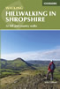 Guidebook to 32 walking routes in Shropshire in the West Midlands. The routes range from 3 miles (5km) to 12 miles (19km), taking in highlights such as The Wrekin, Wenlock Edge, Long Mynd and Stiperstones, Castle Ring and Bury Ditches. Many routes start near delightful towns and villages including Church Stretton, Ludlow and Bishops Castle.
More information
Messaging & Social Media
Message Walking Britain and follow the latest news.

Mountain Weather
Stay safe on the mountains with detailed weather forecasts - for iOS devices or for Android devices.