Walk 2470 - printer friendly version
West Wycombe & Bledlow Ridge Walk
Author - Lou Johnson
Length - 8.2 miles / 13.3 km
Ascent - 1050 feet / 318 metres
Grade - moderate
Start - OS grid reference SU826947
Lat 51.6450420 + Long -0.8076363
Postcode HP14 3AP (approx. location only)
A lovely walk from West Wycombe exploring the farmland, hills, and woodland of the Chilterns. The route follows paths, quiet lanes and tracks proving some excellent views across the rolling landscape. The walk also includes the landmark of St Lawrence Church and the adjacent Dashwood Mausoleum.
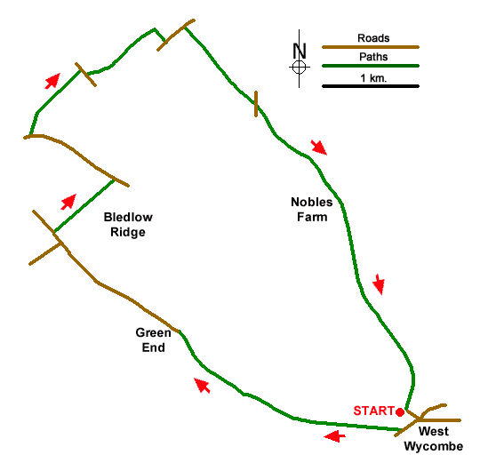
The walk starts from the Chorley Road car park (grid ref. SU826947) just off the A40 at the west end of the village. After parking exit the parking area and turn right to the roundabout. Turn right onto the A40 and after 200 metres turn right at the fingerpost to enter a field. Walk half-left across the field and maintain direction across the next two fields to enter Great Cockshoots Wood. Follow the path through the wood which is marked with white arrows. Reaching a T-junction, turn right and after 50 metres turn left to continue along the onward path heading northwest. Continue to reach a pond near Green End Farm. Turn right along an enclosed path which leads to the farm's access drive. Follow this to join a lane at Hatch End (grid ref. SU804955).
Turn left along Green End Road. After just under a kilometre, you pass Pond Farm on your right and a pond on your left. Continue ahead for a further 200 metres to reach Radnage Common Road on your left. Continue ahead and take the next signed bridleway on the right. Pass through a wooden gate and follow the clear path as it descends to reach Bottom Road (grid ref. SU798970). Turn left and continue for a kilometre and just after a water treatment plant on the right, turn right up a path leading onto the partially wooded Bledlow Ridge. Reaching a cross path, turn right and immediately left still climbing. Keep ahead at the first junction and at the next junction (by a noticeboard), turn right to join the Chiltern Way.
Reaching Chinnor Road (grid ref. SU795981), turn right. (If in need of refreshment then the Boot Inn is a short distance to the left.) Just past a large house on the left (Waverley) turn left along an enclosed path. The path heads downhill passing through three kissing gates to reach a farm track. Turn right and continue to just before reaching Haw Lane. Turn left on a path running parallel to the road and at the end of the field, bear right to the road. Cross the road to the footpath opposite and slightly left.
The onward path crosses several stiles as it makes its way across Slough Hill before descending to a lane (grid ref. SU812977). Cross the lane to a stile and join a tarmac track which takes you to Nobles Far. The path continues along the ridge to pass Windyhaugh House on your left and shortly after to reach the Golden Ball car park. Walk across the car park to explore St Lawrence Church and the Dashwood Mausoleum. From the latter, take the wide grassy path downhill. You have a choice either to return to the car park or explore West Wycombe village.
Messaging & Social Media
Message Walking Britain and follow the latest news.

Mountain Weather
Stay safe on the mountains with detailed weather forecasts - for iOS devices or for Android devices.