Great Allotment & God's Bridge from Bowes
Moorland Walk + Riverside Walk + Pub Walk
Region - North Pennines
County/Area - Durham
Author - Lou Johnson
Length - 10.2 miles / 16.6 km Ascent - 920 feet / 279 metres
Time - 6 hours 0 minutes Grade - moderate
Maps 

| Ordnance Survey Explorer OL31 | Sheet Map | 1:25k | BUY |
| Anquet OS Explorer OL31 | Digital Map | 1:25k | BUY |
Walk Route Description
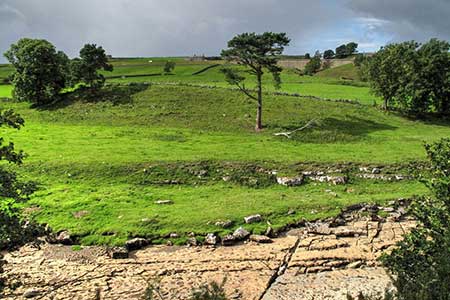
Click image to see photo description.
Walk from Bowes in County Durham exploring open moorland and the Greta Valley. The route uses sections of the Pennine Way including the main path and the Bowes Loop. Bowes is an interesting village with the remains of 12th century Bowes Castle and a Roman Fort.
The walk starts from the car park opposite Bowes Village Hall (grid ref. NY996135). After parking walk to the nearby roundabout and turn left up The Street, signed no access to A66. Nearing the edge of the village the road bends right, crosses the A66 and continues ahead. You are now following the Pennine Way (Bowes Loop). The road passes allotments on the right and starts to climb steadily. Keep ahead at the next junction. And continue across open moorland. The next landmark are the signs prohibiting access the former site of RAF Bowes Moor which was used to store chemical weapons during World War II.
As the road descends, turn left at a fingerpost across a wall stile (grid ref. NY978148). Follow the path across fields to reach the access drive for West Stoney Keld and turn right. Go straight across the first junction and follow a clear track which leads to Levy Pool Farm (grid ref. NY968154). Pass to the left of the buildings, cross a footbridge over Deepdale Beck and turn right. The path initially runs beside the Beck but soon arcs left and starts to climb. The grassy path continues (roughly north) across the moor to reach a clear track after a kilometre (grid ref. NY968164). There is a get on your right.
Turn left, leaving the Bowes Loop, and follow what is initially a clear track across the Great Allotment. The track soon becomes a grassy path with sections of soft ground to negotiate. After 2.5 kilometres of walking, you reach gate in a wall (grid ref. NY942160). Go through the gate and turn left to join the main route of the Pennine Way. The path descends with a wall on your left into Sled Dale. Cross a footbridge and join the rising path on the other side. Keep to the right of a barn, cross a track, and keep to the rising path signed Pennine Way. The onward route crosses open moorland with a few cairns dotted along the path. After crossing Ravock Castle (hill)the path descends soon crossing a wet area to reach a wall corner. Follow the path beside the wall on your left to reach a cottage. Turn sharp right and use the underpass to cross the A66 (grid ref. NY954128).
Once out of the underpass turn left and then right along a track past a house to God's Bridge over the River Greta. Once across the river, turn left through a get to join an excellent riverside path with the Greta on your left. After 600 metres you reach a path junction. Fork left and continue along the clear path as it runs beside the river eventually re-joining the Pennine Way (Bowes Loop) again (grid ref. NY968128). Continue east along the Pennine Way. The path turns right in front of West Charity Farm to follow the farm's access drive. Continue past Lady Myres Farm (on your right). Just past the farm the Pennine Way leaves the track to the left and continues to a footbridge over the Greta (grid ref. NY984131).
Once across the bridge turn right briefly along the riverbank. You soon veer left to join a walled track that passes the buildings at Swinholme. Just after the track bends left, turn right onto a field path which runs behind the houses of Bowes on your left. Just after passing the remains of Bowes Castle, the route turns left along a walled lane with the parish church on your right. Reaching the main street through Bowes, turn right and return to the parking area.
Other walks nearby
| Walk 1553 | Hannah's Meadow, Baldersdale & Brown Rigg Moss | easy/mod | 8.0 miles |
| Walk 2157 | Romaldkirk & Cotherstone | easy | 5.0 miles |
| Walk 2170 | Eggleston & Mickleton from Romaldkirk | easy/mod | 5.8 miles |
| Walk 2228 | Romaldkirk Moor | easy/mod | 7.6 miles |
| Walk 1253 | Booze & Slei Gill from Langthwaite | easy | 2.5 miles |
| Walk 3478 | Cringley Hill & Scar House from Langthwaite | easy/mod | 4.8 miles |
| Walk 1768 | Thomas Gill and Ravenseat from Tan Hill | moderate | 8.7 miles |
| Walk 1005 | Harter Fell & Grassholme | moderate | 8.0 miles |
| Walk 1482 | Crossthwaite Common from Middleton-in-Teesdale | moderate | 9.8 miles |
| Walk 1483 | Eggleston & Romaldkirk from Middleton-in-Teesdale | easy/mod | 9.8 miles |
Recommended Books & eBooks
The Pennine Way - the Path, the People, the Journey
 A portrait of the The Pennine Way, Britain's oldest and best known long-distance footpath, stretching 268 miles from the Peak District to the Scottish Borders. This personal, thoughtful and often humorous story of the path's remarkable history, includes the experiences of walkers and local characters on this exhilarating and complex path.
More information
Walking in the North Pennines
 This guidebook describes 50 day walks across the North Pennines, England's remotest Area of Outstanding Natural Beauty taking in parts of Cumbria, County Durham and Northumberland. Most of the routes are circular and they range from 5 to 14 miles, with something to suit all abilities. Route descriptions are accompanied by 1:50K OS mapping.
More information
Messaging & Social Media
Message Walking Britain and follow the latest news.

Mountain Weather
Stay safe on the mountains with detailed weather forecasts - for iOS devices or for Android devices.