Walk 2467 - printer friendly version
Green Crag & Harter Fell Walk
Author - Lou Johnson
Length - 7.9 miles / 12.8 km
Ascent - 2300 feet / 697 metres
Grade - moderate
Start - OS grid reference NY213011
Lat 54.3992590 + Long -3.2137479
Postcode CA19 1TH (approx. location only)
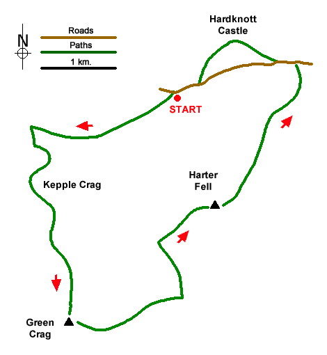
Circular Walk from Jubilee Bridge is Eskdale at the foot of the Hardknott Pass. The route includes two Wainwrights, Green Crag and Harter Fell. Expect some soft ground and take a map as the paths fade and reappear at regular intervals. Nearing the end of the walk, you cross the site of Hardknott Fort which must rank as one of the most scenic locations for a Roman fortification.
There is a small car park near Jubilee Bridge (grid ref. NY213011). After parking exit the parking area, cross Jubilee Bridge to join a signed public bridleway. After path passes through the second gate fork right off the bridleway to join a feinter path. This path is followed for nearly two kilometres. Approaching Penny Hill Farm, the path becomes a grassy track, to reach a junction with remains of buildings on the right (grid ref. NY195007). Turn left and follow what was a former peat road which leads through pastures onto open country to pass through the intake wall (grid ref. NY197004) by a sheepfold.
After a short way, a path veers left adjacent to a wall with a clearer path veering away from the wall. The path soon trends southwest and passes to the right of Kepple Crag. After passing this crag, the path trends southeast through a shallow valley. Exiting the valley and with the crags of Great Whinscale ahead, turn south and choose the best line over The Pike. After a short descent, continue up to the summit of Green Crag where the highest point is marked by a cairn. The view is excellent and includes the next Objective Harter Fell.
To start the descent, head south-southeast and aim for the right-hand corner of a plantation in view ahead to locate a gate in the intake wall. Bear left, cross Grassguards Gill twice and head north through the plantation on reasonable path to exit at a get (grid ref. SD211992). Turn right and choose a suitable route up the western flank of Harter Fell. The going is steep in places but soon the summit of Harter Fell is reached with an OS trig point. The highest point requires a mild scramble over rocks.
To descend initially walk east, the path soon veers northeast and descends easily to reach a stile. Cross the stile and continue downhill soon reaching the edge of a planation. Pick up the path with a fence briefly on your right. Continue to reach the road over Hardknott Pass. Turn left and descend for 300 metres. Approaching a hairpin bend continue ahead on a signed path. The path passes below Border End and to reach a flat area which is the site of Hardknott Fort. Pass through the remains of the fort and return to the road. Turn right and continue to descend back to the start at Jubilee Bridge.
Messaging & Social Media
Message Walking Britain and follow the latest news.

Mountain Weather
Stay safe on the mountains with detailed weather forecasts - for iOS devices or for Android devices.