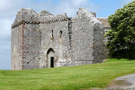
Cheriton & Weobley Castle from Landimore
Gower Peninsula Walk
Region - Gower Peninsula
County/Area - Swansea
Author - Lou Johnson
Length - 5.2 miles / 8.5 km Ascent - 600 feet / 182 metres
Time - 3 hours 10 minutes Grade - easy/mod
Maps 

| Ordnance Survey Explorer 164 | Sheet Map | 1:25k | BUY |
| Anquet OS Explorer 164 | Digital Map | 1:25k | BUY |
Walk Route Description
Click image to see photo description.
Starting from Landimore in the Gower Peninsula this varied walk includes a wide expanse of tidal salt marsh, the picturesque valley of Burry Pill, the standing stone of Samson Jack and the 14th century fortified manor house of Weobley Castle.
The walk starts from the end of the road at Landimore where there is parking for a few cars (grid ref. SS465935). After parking follow the Wales Coast Path easy with the slat marshes to your right. Follow the clear track with woodland on your left which covers the limestone scarp or Tor Gro. 1.5 kilometres from the start you pass North Hill Tor after which the path turns inland with the Burry Pill on your right meandering between salt marshes. Continue across a footbridge and then bear left along the high tide alternative of the Wales Coast Path (grid ref. SS450936). The path keeps to the right-hand edge of two fields to reach a track enclosed by hedges. Turn right and continue to the road.
Turn right along the road and walk into Cheriton. Reaching the Church of Saint Cadoc, take the footpath on the left (signed to Stembridge). After passing through a woodland you reach a path junction. Fork right here and continue up the valley with Burry Pill on your right. Follow the path up the valley ignoring any paths to the right and left and exit onto the road at Stembridge (grid ref. SS468918). Turn left up the road and keep right at the next junction. Pass Stonebridge Farm on your right. 150 metres beyond the farm veer left onto a signed footpath through a metal gate. The path keeps to the left-hand side of several fields top pass a large standing stone named Samson's Jack. Continue ahead to Windmill Farm where you join their access drive to a road (grid ref. SS478925).
Turn left and then right into the entrance to Weobley Castle (also with footpath sign). Follow the drive for a short distance and then turn left through a gate waymarked with a yellow arrow. Once through the gate bear right and follow the path down towards the shoreline. Turn left along the Wales Coast Path and return to Landimore. The path runs beside Hambury Wood on your left and continues into the centre of the village. Reaching a road, turn right and return to the start of the walk.
Other walks nearby
| Walk 1691 | Whiteford Point & Broughton Bay from Llanmadoc | easy/mod | 8.5 miles |
| Walk 2724 | Whiteford Sands from Llanmadoc | easy | 5.1 miles |
| Walk 1960 | Worms Head from Pilton Green | easy/mod | 7.5 miles |
| Walk 2144 | Port-Eynon from Pilton Green | easy/mod | 6.4 miles |
| Walk 2424 | Harding's Down & Rhossili Down | moderate | 9.0 miles |
| Walk 3258 | The Beacon from Rossili | easy | 4.0 miles |
| Walk 1967 | Worms Head from Rhossili | easy | 3.3 miles |
| Walk 2277 | Oxwich Point Circular from Oxwich | easy/mod | 3.5 miles |
| Walk 2287 | Cefn Bryn & Penrice | easy/mod | 7.7 miles |
| Walk 3761 | Cefn Bryn & Three Cliffs Bay from Penmaen | moderate | 9.0 miles |
Recommended Books & eBooks
No suggestions for this area.Messaging & Social Media
Message Walking Britain and follow the latest news.

Mountain Weather
Stay safe on the mountains with detailed weather forecasts - for iOS devices or for Android devices.