Cregennen Lakes & Pared y Cefn-hir
Snowdonia/Eryri Walk
Nat Park - Snowdonia - Cadair Idris
County/Area - Gwynedd
Author - Lou Johnson
Length - 2.5 miles / 4.1 km Ascent - 560 feet / 170 metres
Time - 1 hours 50 minutes Grade - easy/mod
Maps 

| Ordnance Survey Explorer OL23 | Sheet Map | 1:25k | BUY |
| Anquet OS Explorer OL23 | Digital Map | 1:25k | BUY |
Walk Route Description
Click image to see photo description.
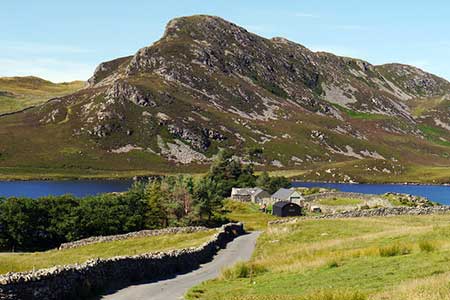
This short walk from the Cregennen Lakes below Cadair Idris offers exceptional views of many mountains in Snowdonia (Eryri). The route starts by the western lake and climbs up a ridge to the summit of Pared y Cefn-hir. There is a short section of easy scrambling which is more than compensated by the view from the summit. The walk continues down an undulating ridge before descending into a valley to return to the start.
The start is the free National Trust car park (grid ref. SH658143) which can be reached via a lane (signed to Llynnau Cregennen) from the A493 near Arthog which runs along the south side of the Mawddach Estuary. After parking turn left along the road with the lake on your right. Continue along the road which starts to rise and take the signed footpath on the right. Follow the grassy path to a wall and stile. Cross the stile and where the path forks bear left and follow the grassy path uphill.
The path rises steeply. Thankfully, it is only a short ascent. About half-way up there is a short scramble which can be avoided by a faint path to the right. The path continues to climb and soon reaches the summit of Pared y Cefn-hir. From the summit you get a bird's eye view across the Cregennen Lakes to the great cliffs of Cadair Idris. North the view includes the Mawddach Estuary with the Rhinog mountains rising beyond.
To continue follow a clear undulating path along the wide ridge to reach the remains of an old hill fort. Leaving the fort, the path continues along the ridge losing some height before climbing for a short distance. The path then descends to a stream (grid ref. SH668154) with the rocky outcrop of Pen Moelyn ahead. Turn right at the stream and follow a narrow path through heather downhill. Continue down to a wall and turn right onto a clearer path keeping the wall on your left. This path leads beside the lake to reach the stile used at the beginning of the walk. Reaching the road, turn left and retrace your steps back to the car park.
Other walks nearby
| Walk 3229 | Mawddach circular | moderate | 9.0 miles |
| Walk 2450 | Llynnau Cregennen & Mawddach Estuary | moderate | 8.4 miles |
| Walk 1172 | Cadair Idris by the Pony Path | mod/hard | 11.0 miles |
| Walk 2668 | Cadair Idris, Craig Cau and Cyfrwy by the Pony Path | mod/hard | 5.3 miles |
| Walk 1644 | Cregennen Lakes | moderate | 11.0 miles |
| Walk 1647 | Mawddach Bridge and Arthog | easy | 5.4 miles |
| Walk 2570 | Cadair Idris from Llanfihangel-y-pennant | mod/hard | 10.0 miles |
| Walk 2707 | Tyrrau Mawr and Craig-y-llyn from Llanfihangel-y-pennant | moderate | 9.5 miles |
| Walk 1643 | Llanfihangel-y-pennant & Castell y Bere | easy/mod | 6.8 miles |
| Walk 3582 | Castell y Bere & Llanfihangel-y-pennant from Abergynolwyn | easy/mod | 5.7 miles |
Recommended Books & eBooks
Mountain Walking in Snowdonia
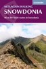 Guidebook to 40 of Snowdonia's best day walks, with routes up Snowdon and Tryfan, including the Snowdon Horseshoe, Cadair Idris, Y Garn and The Rhinogs. The routes range from Grade 1 scrambles like Crib Goch or Bristly Ridge, to riverside and forest walks. Includes details of a 2-day traverse of all 15 of Snowdonia's 3000ft peaks.
More information
Snowdonia: 30 Low-level and easy walks - South
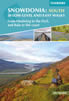 Guidebook describing 30 walks in Snowdonia, Wales. Routes are mostly low level and on clear paths and showcase the region's beautiful scenery and rich history and culture. Part of a 2-volume set, this southern volume includes Trawsfynydd, Bala, Dolgellau, Machynlleth, the Harlech Coast and the valleys of the Mawddach and Dyfi.
More information
Messaging & Social Media
Message Walking Britain and follow the latest news.

Mountain Weather
Stay safe on the mountains with detailed weather forecasts - for iOS devices or for Android devices.