Sharp Haw in Airedale from Craven Heifer
Yorkshire Dales Walk
Nat Park - Yorkshire Dales - Lower Wharfedale
County/Area - North Yorkshire
Author - Phil Catterall
Length - 7.0 miles / 11.4 km Ascent - 1140 feet / 345 metres
Time - 4 hours 40 minutes Grade - easy/mod
Maps 

| Ordnance Survey Explorer OL2 | Sheet Map | 1:25k | BUY |
| Anquet OS Explorer OL2 | Digital Map | 1:25k | BUY |
| Ordnance Survey Landranger 103 | Sheet Map | 1:50k | BUY |
| Anquet OS Landranger 103 | Digital Map | 1:50k | BUY |
Walk Route Description
Click image to visit gallery of 4 images.
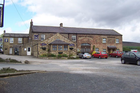
This is a great half day Yorkshire Dales circular walk taking in the Marilyn Summit of Sharp Haw (1171 ft/357m). The start is the car park of the Craven Heifer pub (grid ref. SD 983534) on the B6265 one mile north of Skipton town centre. You may wish to support the pub by spending some time there for a drink or meal as we did. I recommend it. The landlady will welcome you and allow you to park up for the duration of your walk. Sharp Haw can be seen like a "Mini Matterhorn" to the north west of the car park. Looking north east you see Embsay Moor which is topped by Cracoe Fell - another walk for later this year.
Walk north of the pub on the busy B6265 for 200m before taking the footpath on your left opposite the road junction. The path soon turns into a track and you reach a country lane north of the Tarn House Hotel and campsite. Leaving the track continue straight ahead on the lane which bends sharp right and then left. On the next right hand bend we take the gated track that goes straight on. As an alternative you could start the walk from this gateway; however your vehicle will be less secure than if you parked it at the Craven Heifer. There is room for at least three cars.
We now start the gradual ascent to Sharp Haw as we leave the track and follow a neat grassy path to the summit. There is a bench, a stile, a trig point and dry stone walling on the top. We leave the hilltop and head NNE to rejoin the bridleway going north, keeping to the left of Rough Haw, the adjoining hill. The bridlepath now meanders downhill on account of the boggy ground caused by several springs emerging in this part of Airedale. Careful walking should keep you out of trouble. We emerge at grid reference SD948566 on the outskirts of Flasby - the hamlet where Sir Fred Trueman, the famous Yorkshire cricketer had his family home. Fred had a sports shop in Skipton at one time.
As soon as we reach the path junction before the river we turn left along a fresh tarmac road towards New Laithe Farm and Septeria Gill. As we start to climb again the track sweeps left and then right before a gate at High Wood. We enter the wood and keep to the western side on the forestry tracks. Much of the wood to our right has been felled and replanted (July 2008). At the path junction at grid reference SD953555 we take the right hand path, and although this short section can be fairly boggy, it is far worse if you take the left fork. Both paths end up in the same place at the bottom end of the wood.
The path becomes a well maintained forestry road with views of Gargrave, the River Aire and the Leeds and Liverpool Canal. Continue walking south east until the track starts to turn north at grid reference SD966541. A stile lies at this point but we found access to it overgrown in summer with nettles and brambles. Walk 100m north along the track and there is an unlocked gate on your right, so use this if necessary. The footpath drops down into a gully (grid ref. SD 969540) but this is easily negotiated. Take the next stile to keep you on the right hand side of the wall. The path then takes you out to the lane near Tarn House Hotel and campsite. Once the lane is reached turn left and walk 200m uphill to reach the point you were at around 2 hours previously. Turn right along the track to return to the Craven Heifer pub or continue on the lane if you parked your vehicle in the less secure gateway mentioned earlier.
Other walks nearby
| Walk 3107 | Flasby Fell from Flasby | easy/mod | 6.5 miles |
| Walk 3307 | Gargrave to Flasby | easy/mod | 6.5 miles |
| Walk 2657 | Bradleys Both, near Skipton | easy/mod | 5.5 miles |
| Walk 3109 | Rylstone Edges & Cracoe from Rylstone | easy/mod | 6.0 miles |
| Walk 1576 | Embsay Reservoir | easy | 1.0 miles |
| Walk 2066 | Winterburn Reservoir circular | easy | 6.0 miles |
| Walk 2861 | Pinhaw Beacon from Lothersdale | easy | 4.0 miles |
| Walk 1946 | Valley of Desolation & Simon's Seat | moderate | 8.4 miles |
| Walk 2304 | East Marton and the Drumlins | easy/mod | 5.5 miles |
| Walk 3430 | Farnhill Moor from Kildwick | easy/mod | 4.5 miles |
Recommended Books & eBooks
Walking in the Yorkshire Dales: South and West
 Part of a two-book set, this guidebook describes 44 walks in the southern and western Yorkshire Dales, including the famous 23 mile Three Peaks circuit over Pen-y-Ghent, Whernside and Ingleborough. The other, mostly circular routes of 3½ to 13 miles cover the scenic region between Sedbergh, Kirkby Lonsdale, Settle, Skipton and Grassington.
More information
Walking in the Yorkshire Dales: North and East
 This guidebook contains 43 circular day walks in the north and east Yorkshire Dales. It explores the dales, hills and moors between Kirkby Stephen and Pateley Bridge. Walking ranges from gentle 3 mile strolls to more strenuous day-long rambles across the Howgills, Wensleydale, Swaledale, Nidderdale, Mallerstang and Coverdale.
More information
Messaging & Social Media
Message Walking Britain and follow the latest news.

Mountain Weather
Stay safe on the mountains with detailed weather forecasts - for iOS devices or for Android devices.