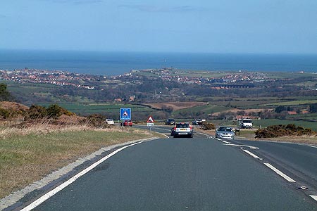
Sleights Moor from Blue Moor
North York Moors Walk
Nat Park - North York Moors - North York Moors East
County/Area - North Yorkshire
Author - Andy Chaplin
Length - 7.8 miles / 12.6 km Ascent - 950 feet / 288 metres
Time - 4 hours 50 minutes Grade - easy/mod
Maps 

| Ordnance Survey Explorer OL27 | Sheet Map | 1:25k | BUY |
| Anquet OS Explorer OL27 | Digital Map | 1:25k | BUY |
| Ordnance Survey Landranger 94 | Sheet Map | 1:50k | BUY |
| Anquet OS Landranger 94 | Digital Map | 1:50k | BUY |
Walk Route Description
Click image to see photo description.
This North York Moors walk takes in the views along the Esk Valley from Whitby to Grosmont, the Murk Esk valley towards Goathland and Iburndale back towards Sleights. It starts from probably the best parking place for miles around - at the top of Blue Bank at grid ref. NZ868058. The lack of well-maintained paths from here suggests the two car-parks are provided to take in the view towards Whitby and the coast - or to check your brakes before hurtling down Blue Bank.
From the car parks cross the A169 and go through the gate into the old quarry opposite. There are still some quarrying vehicles around so take care for the first 100 metres or so. The official path starts a little south - down the road at a stile - but it quickly crosses back into to the old quarry workings - so take your pick.
The path is not well defined over the old, grassed spoil heaps but becomes a moors track as it gets to the boundary wall on your right from where it heads towards another of the new Esk valley beacons. There are good views from here into the Esk valley and you may see steam trains running on the main line track between Whitby and Grosmont on some summer weekends when the NYMR extends their service from the preserved Pickering-Grosmont line.
Towards the end of Lowther's Crag the path becomes a track going into another quarry or stone masons area to reach a road (grid ref. NZ845050). Cross the road and continue along the edge of the moor towards Greenlands Farm. Before you reach the farm the route descends to Spa Hill Slack where you cross the stream before climbing up through ferns to reach Greenlands Farm.
Continue on around Arundel Hill to pick up the line of the old quarries on Whinstone Ridge at grid ref. NZ837035. You can take paths either in the old quarries or along the southern edge. Note that at the top of these quarries you will have a better view into the Murk Esk valley towards Goathland where the crushing plant for the whinstone from the Sil Howe mine used to be.
Cross the A169 (grid ref. NZ855026) and continue in a straight line along the whinstone ridge towards the Newton House plantation. At grid ref. NZ860024 turn left along the path. However the old marked footpaths here seem to have become less used as there is a new track alongside the pylons. Follow this newer track northwards until you join a track at right-angles (grid ref. NZ863047), Turn right towards High Quebec Farm. As you approach the farm there is a sign directing you north (left) on a track towards Little Beck.
After half a kilometre, at another track crossroads (grid ref. NZ869047) you can look for the path straight-ahead (north) which will lead back uphill to the parking. However this path was not very clear in early 2014 and you need to use your map reading skills to reach the car park. Alternatively, turn right down the track towards Little Beck which will give you a chance to see some of this quite little valley. Watch out for traffic on the steep, narrow roads. At the end of the track take the road past Spring Farm and Goathland Banks before finding the short path off to the left (grid ref. NZ869057), just before the kennels, and cross fields, go under the pylons and fight your way through the bracken back to the car parks.
Other walks nearby
| Walk 1758 | Newton House Plantation & Stony Leas | moderate | 10.3 miles |
| Walk 1743 | Sneaton Thorpe & Littlebeck from May Beck | moderate | 8.9 miles |
| Walk 2583 | Iburndale and the Esk Valley from Stainsacre | moderate | 10.3 miles |
| Walk 3533 | Mallyan Spout and Beck Hole from Goathland | easy | 3.0 miles |
| Walk 2262 | Goathland & Grosmont | easy/mod | 7.7 miles |
| Walk 2130 | Robin Hood's Bay & Hawkser from Fylingthorpe | moderate | 10.0 miles |
| Walk 2563 | Egton Bridge & Grosmont from Goathland | moderate | 12.5 miles |
| Walk 1922 | Goathland & Howl Moors | moderate | 11.2 miles |
| Walk 2091 | Kettleness and Mickleby from Lythe | moderate | 9.7 miles |
| Walk 1675 | The Esk Valley & Egton High Moor | moderate | 10.5 miles |
Recommended Books & eBooks
Trail and Fell Running in the Yorkshire Dales
 Guidebook to 40 of the best trail and fell runs in the Yorkshire Dales National Park. Ranging from 5 to 24 miles, the graded runs start from bases such as Ribblehead, Dent, Sedbergh, Malham and Grassington and take in the region's diverse delights, from castles and waterfalls to iconic mountains such as Whernside, Ingleborough and Pen Y Ghent.
More information
Messaging & Social Media
Message Walking Britain and follow the latest news.

Mountain Weather
Stay safe on the mountains with detailed weather forecasts - for iOS devices or for Android devices.