Simon's Seat from Bolton Abbey
Yorkshire Dales Walk
Nat Park - Yorkshire Dales - Lower Wharfedale
County/Area - North Yorkshire
Author - Lou Johnson
Length - 10.0 miles / 16.3 km Ascent - 1435 feet / 435 metres
Time - 6 hours 30 minutes Grade - moderate
Maps 

| Ordnance Survey Explorer OL2 | Sheet Map | 1:25k | BUY |
| Anquet OS Explorer OL2 | Digital Map | 1:25k | BUY |
| Ordnance Survey Landranger 104 | Sheet Map | 1:50k | BUY |
| Anquet OS Landranger 104 | Digital Map | 1:50k | BUY |
Walk Route Description
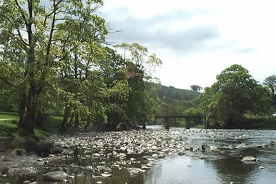
Click image to visit gallery of 12 images.
This is a Yorkshire Dales walk of contrasts and includes moorland, two rocky summits, woodland and beautiful riverside paths. Unusual for a walk of this length the route is over good paths throughout and navigation problems are minimal. The start, reached by a drive off the B6160, is the car park adjacent to the Cavendish Pavillion (Grid ref. 077551). There is a charge and once you have paid you can use other car parks within the Bolton Abbey Estate. Please note that dogs are not allowed on the moorland sector of this walk.
From the car park walk north alongside the River Wharfe to reach a wooden bridge (marked as such on the OS 1:25000 map). Cross the bridge and turn left along the clear footpath along the river bank heading north (upstream). After a short way this rises to join a metalled lane. Stay on the lane and climb slightly to reach a gatehouse on your right. Adjacent to this is a waymarked path signed "Simon's Seat". Take this path passing through pastures at first but soon entering a valley. You will notice a footbridge down on your left (Grid ref. 078566). Cross this and follow the narrow path upstream to pass a waterfall.
Above the waterfall you enter the 'Valley of Desolation' before the path enters a conifer plantation. You are soon through the sombre trees and exit onto open moorland. The onward path is obvious and climbing gently the gritstone rocks that mark the summit of Simon's Seat soon come into view. The bird's eye perspective of Wharfedale is particularly fine and it is a perfect place for a break. A short optional visit may be made to Lord's Seat, which lies about 500 metres east. This sees fewer visitors and offers views towards Nidderdale.
To locate the onward path head to the southwestern corner of the summit rocks. You will find a paved path descending steeply north into the valley. The grade soon eases and you continue to descend through a series of zig-zags to reach a walled track at Dalehead Farm (Grid ref. 075604). Turn left (west) along this pleasant lane to reach a junction of tracks at Howgill (Grid ref. 063591). Turn right to reach a road. Cross the road and join the Dales Way heading south along the east bank of the River Wharfe. This leads pleasantly to Barden Bridge.
Do not cross the river instead continuing on the Dales Way. The path stays on the east bank as far as a substantial stone bridge where it crosses to the other bank. The path then continues through beautiful woodland to the Strid where the River Wharfe squeezes through rocks before continuing at a gentler pace a few hundred metres downstream. The final section from the Strid to the Cavendish Pavillion follows the river passing through woodland maintained by the Estate.
Other walks nearby
| Walk 2574 | Valley of Desolation & Barden Fell | moderate | 11.0 miles |
| Walk 1946 | Valley of Desolation & Simon's Seat | moderate | 8.4 miles |
| Walk 1905 | Beamsley Beacon and Bolton Abbey | moderate | 10.0 miles |
| Walk 2942 | Below Silsden Moor | easy/mod | 6.8 miles |
| Walk 1280 | Trollers Gill | moderate | 9.0 miles |
| Walk 2000 | Wharfedale Circular | moderate | 13.5 miles |
| Walk 1574 | Thruscross Reservoir | easy | 4.5 miles |
| Walk 2319 | Ilkley to Bingley | easy/mod | 7.0 miles |
| Walk 1576 | Embsay Reservoir | easy | 1.0 miles |
| Walk 1573 | Grimwith Reservoir | easy | 4.5 miles |
Recommended Books & eBooks
Walking in the Yorkshire Dales: North and East
 This guidebook contains 43 circular day walks in the north and east Yorkshire Dales. It explores the dales, hills and moors between Kirkby Stephen and Pateley Bridge. Walking ranges from gentle 3 mile strolls to more strenuous day-long rambles across the Howgills, Wensleydale, Swaledale, Nidderdale, Mallerstang and Coverdale.
More information
Walking in the Yorkshire Dales: South and West
 Part of a two-book set, this guidebook describes 44 walks in the southern and western Yorkshire Dales, including the famous 23 mile Three Peaks circuit over Pen-y-Ghent, Whernside and Ingleborough. The other, mostly circular routes of 3½ to 13 miles cover the scenic region between Sedbergh, Kirkby Lonsdale, Settle, Skipton and Grassington.
More information
Messaging & Social Media
Message Walking Britain and follow the latest news.

Mountain Weather
Stay safe on the mountains with detailed weather forecasts - for iOS devices or for Android devices.