Thornthwaite Beacon & High Street from Hartsop
Lake District Walk
Nat Park - Lake District - Lake District Far Eastern Fells
Wainwrights - High Street, The Knott, Thornthwaite Crag
County/Area - Cumbria
Author - Lou Johnson
Length - 6.5 miles / 10.6 km Ascent - 2460 feet / 745 metres
Time - 5 hours 40 minutes Grade - moderate
Maps 

| Ordnance Survey Explorer OL5 | Sheet Map | 1:25k | BUY |
| Anquet OS Explorer OL5 | Digital Map | 1:25k | BUY |
| Ordnance Survey Landranger 90 | Sheet Map | 1:50k | BUY |
| Anquet OS Landranger 90 | Digital Map | 1:50k | BUY |
Walk Route Description
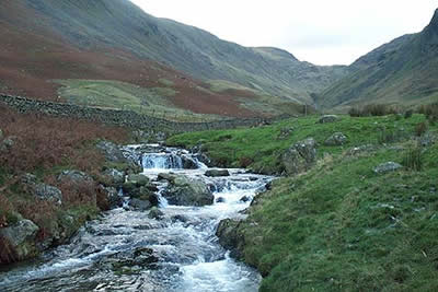
Click image to visit gallery of 9 images.
This is a relatively short excursion into the higher fells of the eastern Lake District. Despite its length it has plenty to offer especially when the weather was as dramatic on the day when these pictures were taken. The start is in the picturesque village of Hartsop, which is a short drive off the A592 at the northern end of Kirkstone Pass, where limited parking is available at the far end of the village (grid ref. NY410130). If this is full then alternative parking is often available at Cow Bridge (grid ref. NY402134) just off the A591. However the latter adds about a mile on tarmac to the route.
After parking go through the gate and turn right taking the track to cross the bridge onto the southern side of the beck. Stay on this track through fields to reach open country in Pasture Bottom (grid ref. 417123). By now you are in a fine u-shaped valley with Gray Crag to your left and the slopes of Hartsop Dodd to your right. Ahead you can see the path climbing steadily.
Keep with the path. It steepens as it threads its way through glacial moraines to reach an area that must have once held a tarn. This is Threshthwaite Cove with a col ahead. The real "collar work" starts as the path climbs steeply to this col - Threshthwaite Mouth - from where the reward is a fine view south to Windermere. Turn left and follow the clear path for Thornthwaite Beacon. The going remains steep until you reach the summit plateau, which is adorned with a well-built cairn of substantial proportions. This point is a good place for a break as a wall provides shelter. It also offers some impressive Lake District views.
The onward route takes us to the summit of High Street along a broad well walked path. The trig point is behind the wall from where a short stroll east takes you to the top of Long Stile and a wonderful bird's eye view of Rough Crag with Mardale far below. After enjoying the view return to the summit and follow the wall north keeping it on your left. This route offers better views into Riggindale than the main path which follows the western flank of High Street. Descending to the Straits of Riggindale you get superb views on both sides. Down to your left is Hayeswater and you will soon be making a closer acquaintance with this on the next section of the walk.
Climbing out from the Straits of Riggindale bear left along a clear path ignoring the main ridge path that continues on to High Raise. Ahead and slightly to your left is the rounded shape of the Knott ( which can be easily climbed for a fine view) with the path contouring around its eastern flank. Descending the view changes with Rest Dodd, Brock Crags and the Angletarn Pikes the dominant summits.
Continuing to descend quite steeply you arrive at the footbridge by the dam at the northern end of Hayeswater. Cross this bridge to reach a track. Turn right and follow this downhill with the splendid waterfalls and cascades of Hayeswater Gill to your right. This track eventually crosses the gill near a tumbledown barn and leads you back to the start.
Other walks nearby
| Walk 1110 | Angletarn Pikes | moderate | 7.0 miles |
| Walk 2060 | The Angletarn Pikes and Brock Crags from Hartsop | moderate | 8.0 miles |
| Walk 3388 | Hayeswater and Angle Tarn from Hartsop | mod/hard | 11.5 miles |
| Walk 2386 | Red Screes via Dove Crag | mod/hard | 8.6 miles |
| Walk 1230 | Birks & Arnison Crag | moderate | 5.5 miles |
| Walk 1520 | Helvellyn & Fairfield Horseshoe from Patterdale | very hard | 13.0 miles |
| Walk 2047 | Place Fell | moderate | 7.5 miles |
| Walk 2425 | Boredale Circular from Patterdale | mod/hard | 11.5 miles |
| Walk 3670 | Angle Tarn and Hayeswater | moderate | 8.3 miles |
| Walk 1156 | Helvellyn via Striding Edge | hard | 9.5 miles |
Recommended Books & eBooks
Outdoor Adventures with Children - Lake District
 Guidebook to 40 outdoor adventures in the Lake District with children under 12, including walking, cycling, orienteering, paddling, boating, hostelling and more. Graded activities for varying age ranges or for families with children of different ages.
More information
Hadrian's Wall Path
 Hadrians Wall Path guidebook to walk the 84 mile National Trail. Described in both directions, the main description is west to east between Bowness-on-Solway and Wallsend, Newcastle, with extensions to Maryport and South Shields. With extensive historical information related to this World Heritage site and separate 1:25,000 OS map booklet included.
More information
Messaging & Social Media
Message Walking Britain and follow the latest news.

Mountain Weather
Stay safe on the mountains with detailed weather forecasts - for iOS devices or for Android devices.