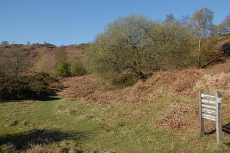
Beacon Tarn & The Beacon from near Torver
Lake District Walk
Nat Park - Lake District - Lake District Lesser Fells
County/Area - Cumbria
Author - Lou Johnson
Length - 4.0 miles / 6.5 km Ascent - 800 feet / 242 metres
Time - 2 hours 50 minutes Grade - easy/mod
Maps 

| Ordnance Survey Explorer OL6 | Sheet Map | 1:25k | BUY |
| Anquet OS Explorer OL6 | Digital Map | 1:25k | BUY |
| Ordnance Survey Landranger 90 | Sheet Map | 1:50k | BUY |
| Anquet OS Landranger 90 | Digital Map | 1:50k | BUY |
Walk Route Description
Click image to visit gallery of 12 images.
This relatively low fell occupies an isolated position just to the west of Coniston Water. As its name suggest, the summit has wide ranging lines of sight to the Cumbrian Coast to the south and the Coniston Fells to the north. As a bonus this Lake District circular walk includes a circuit of Beacon Tarn which nestles in the rugged Lakeland landscape.
The start is the parking area (grid ref. SD289910) on the left side of the A5084 when driving from the Coniston direction and opposite the entrance to Brown Howe car park on the left. There is enough space for a few cars just before the minor road to Stable Harvey. After parking walk alongside the road to Blawith Common. In places you can walk on a small path developing on the verge along the right hand side.
Just after the parking area on the right look out for a wide grassy path on your left (grid ref. SD286901). Follow this ignoring any minor paths going off either side. Go under the power lines and climb to the flank of Slatestone Fell. The path continues down into the valley. Turn right over the bridge and follow this excellent path as far as the outlet to the tarn (grid ref. SD274903).
Bear left and follow the path along the shore of Beacon Tarn (keeping the tarn to your right). You will get a clear view of the Beacon and potential routes to the summit. My choice of route may not have been the easiest but certainly got me to the top very quickly. Continuing to the northern end of the track, I took a direct and unpathed approach up the fell. This involved a zig-zag route following grassy patches until I reached the summit.
The views are superb. Most impressive is probably an almost complete view of Coniston Water. As mentioned in the introduction you also see the Coniston Fells and the Cumbrian Coast plus a great deal more. To descend follow the clear grassy path that heads roughly north. This easy descent takes you down to a narrow tarmac lane (grid ref. SD282914). Turn right and, despite the tarmac, you will enjoy a wonderful little walk through some wonderful Lakeland country. All too soon you reach the main road. Turn left to reach the start.
Other walks nearby
| Walk 1058 | Beacon Fell & Beacon Tarn Circular | easy/mod | 4.0 miles |
| Walk 3110 | The Old Man of Coniston & Dow Crag from Torver | mod/hard | 8.5 miles |
| Walk 3638 | Satterthwaite Bridge Circular | easy | 3.2 miles |
| Walk 3320 | Grizedale Tarn circular | easy | 2.5 miles |
| Walk 1911 | Coniston's Magnificent Seven | hard | 13.0 miles |
| Walk 1217 | Dow Crag & the Old Man of Coniston | mod/hard | 8.5 miles |
| Walk 1761 | Tom Heights and Tarn Hows | easy/mod | 7.0 miles |
| Walk 3028 | Tarn Hows & Tom Gill | easy/mod | 6.5 miles |
| Walk 3220 | Wetherlam via Red Dell | moderate | 7.0 miles |
| Walk 1301 | Great Stickle & Stickle Pike | moderate | 5.0 miles |
Recommended Books & eBooks
Lake District: High Level and Fell Walks
 This guidebook describes 30 graded fell walks on the ridges and high peaks of the English Lake District, the UK's most popular national park. Reaching some of England's finest and highest mountain scenery, this guide leads readers to classic horseshoes and traditional ascents as well as lesser-known routes to quieter summits.
More information
Walking the Lake District Fells - Buttermere
 Part of the Walking the Lake District Fells series, this guidebook covers a wide range of routes to 32 Lakeland summits that can be climbed from the Buttermere, Lorton and Newlands valleys, with highlights including Haystacks, High Stile, Grasmoor and the fells of the Coledale Round. Suggestions for longer ridge routes are also included.
More information
Messaging & Social Media
Message Walking Britain and follow the latest news.

Mountain Weather
Stay safe on the mountains with detailed weather forecasts - for iOS devices or for Android devices.